 Port
PortFlorence: Cinque Terre Day Trip with Optional Hiking or Pisa
5.587 reviews
Buy now
From 49,50€ per person
 Airport
 Attraction
 Citta
Citta Region
 Village
If you’re planning to explore Liguria with your own car or a hire vehicle and want to keep a detailed map of the roads and routes to hand, there’s nothing better than paper road maps.
Here’s the physical map of Liguria, showing the region’s main towns. Click on the image to view it enlarged.
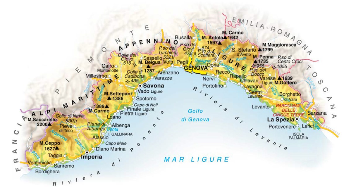
Liguria is one of Italy’s smallest regions, but it’s also one of the most densely populated and the only region in Italy where every province boasts both sea and mountain landscapes.
Bordered by the Ligurian Alps and the Ligurian Apennines to the north and washed by the Ligurian Sea to the south, Liguria combines high mountains, gentle hills, broad valleys and both small and large beaches within its compact territory.
The coast is steep and jagged in the eastern section (Riviera di Levante), whilst to the west (Riviera di Ponente) it alternates sandy beaches with stretches of sheer rocky cliffs.
Liguria borders France to the west, Piedmont to the north, Emilia-Romagna to the north-east, and Tuscany to the south-east.
Administratively, Liguria is divided into four provinces: moving from east to west, you’ll find La Spezia first, then Genoa (the regional capital), Savona and Imperia. Since 1 January 2015, the province of Genoa has been replaced by the Metropolitan City of Genoa.
 Hotel
Hotel  Budget accommodations
  Apartments
  Family Hotel
  Luxury Hotel
  Resorts