Florence: Cinque Terre Day Trip with Optional Hiking or Pisa
5.587 reviews
Buy now
From 49,50€ per person

The Cinque Terre boasts a dense network of marked trails. The best way to discover this territory is on foot, particularly along the Sentiero Verde Azzurro, the most famous route.
The ideal time to plan hikes is between late winter and early spring, when wildflowers of the Mediterranean scrubland begin to bloom. These trails partly follow ancient mule tracks and steep footpaths, so proper footwear and clothing are essential.
The easiest route, running at mid-altitude and connecting all the villages, is the Sentiero Verde Azzurro. The trail uses historic pathways: mule tracks and stone staircases between terraced vineyards create a complete immersion in the landscape. This route is one of Italy’s most celebrated walking trails, both for its manageable difficulty and the breathtaking views it offers the thousands of visitors who walk it year-round.
The route already existed in medieval times and served for centuries as the only communication link between coastal residents. Dozens of mule tracks branch off from the Sentiero Azzurro, climbing towards the ridge and creating an intricate web of paths through dry-stone walls, small settlements and sanctuaries.
You can complete it in a single day, but to truly capture the spirit of the Cinque Terre, breaking it into multiple stages is recommended.
Each of the five villages in the Cinque Terre has a corresponding Sanctuary at mid-altitude, to which locals have long been devoted: five churches connected to their respective villages by steep mule tracks, authentic “Via Crucis” routes still walked by the faithful during annual celebrations.
The Via dei Santuari is the horizontal trail linking all five religious buildings. This historic route is passable on foot, horseback or by bicycle and traverses terraced farmland, vegetable gardens, ancient farmhouses and tiny, often abandoned hamlets.
It’s a straightforward walk within anyone’s reach and can be split into several stages if desired.
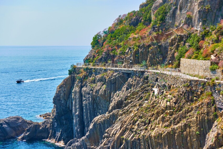
Turn left as you exit Riomaggiore station to find this most celebrated stretch of the Sentiero Azzurro: 900 metres carved into the cliff face high above the sea, connecting Riomaggiore to Manarola. Closed in September 2012 following a landslide, the Via dell’Amore reopened on 14 February 2025 after extensive safety works and restoration. Five artworks by artist Gino Covili have been installed along the route, transforming it into an open-air gallery.
Access is regulated and operates on a one-way system: entry is from Riomaggiore, exit at Manarola. Visitors must book a timed slot with a maximum of 200 entries every 30 minutes; the maximum time allowed for the walk is 30 minutes. Opening hours for 2026 are: 9:00 to 21:00 from 29 March to 24 October; 9:00 to 19:00 from 26 October to 28 March. The path closes if orange or red weather alerts are issued. Always check current conditions on the official Via dell’Amore website before your visit.
Admission cannot be purchased separately: you’ll need the Cinque Terre Card plus a dedicated Via dell’Amore supplement. Visitors staying at CETS Park facilities qualify for reduced rates. Book online in advance, especially during peak season when places sell out quickly.
For those wanting to experience the Cinque Terre from above, away from the crowds on the Sentiero Azzurro, the Alta Via delle Cinque Terre (AV5T, formerly CAI Red Trail no. 1) is the perfect answer. This ridge-top route connects Portovenere to Levanto, covering approximately 35 km with over 1,500 metres of elevation gain, taking 12-13 hours total. It’s not a one-day trail for everyone: the recommended approach is to break it into stages, staying overnight at the Colle del Telegrafo refuge or Santuario di Soviore.
The AV5T’s strength is the completely different perspective it offers of the landscape: the trail runs at elevations between 400 and 800 metres, with 360° views across the villages, terraced vineyards and the Ligurian Sea. Vertical connecting paths mean you can descend to the villages or Val di Vara at any point along the route. The Alta Via is free with the Cinque Terre Card and offers an excellent alternative for those wishing to avoid the overcrowding of the Sentiero Azzurro, especially in July and August.
One of the most rewarding treks in the entire Park and among the few that are completely free. The trail from Levanto to Monterosso via the Punta Mesco promontory offers one of the most iconic views of the Cinque Terre: the viewpoint on the headland lets you take in all five villages in a single sweep.
The route is around 8 km with 350 metres of elevation gain, walkable in 2 hours 30 minutes at a leisurely pace. It doesn’t require the Cinque Terre Card and is accessible year-round in trekking shoes. It’s perfect if you’re staying in Levanto and want to explore the Park on a half-day walk without relying on the train.
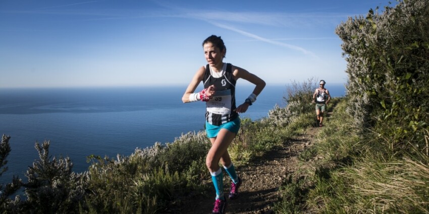
For the very fit, the Sciacchetrail is a 47-kilometre trail with 2,600 metres of elevation gain to be run uphill through the vineyards. Both the start and finish are in Monterosso. An annual speed race is held on the permanent course.
The race’s name recalls Sciacchetrà, the local sweet wine, but also evokes the labour of harvest time, when grape-picking was done entirely by hand, with workers carrying full baskets on their heads. The route touches all five villages and includes tastings of the finest local wines.
 Hotel
Hotel  Budget accommodations
  Apartments
  Family Hotel
  Luxury Hotel
  Resorts